Error message
- Deprecated function: array_key_exists(): Using array_key_exists() on objects is deprecated. Use isset() or property_exists() instead in Drupal\Core\Controller\ControllerResolver->doGetArguments() (line 139 of core/lib/Drupal/Core/Controller/ControllerResolver.php).
- Deprecated function: array_key_exists(): Using array_key_exists() on objects is deprecated. Use isset() or property_exists() instead in Drupal\Core\Controller\ControllerResolver->doGetArguments() (line 139 of core/lib/Drupal/Core/Controller/ControllerResolver.php).
- Deprecated function: array_key_exists(): Using array_key_exists() on objects is deprecated. Use isset() or property_exists() instead in Twig_Template->getAttribute() (line 582 of vendor/twig/twig/lib/Twig/Template.php).
- Deprecated function: array_key_exists(): Using array_key_exists() on objects is deprecated. Use isset() or property_exists() instead in Twig_Template->getAttribute() (line 582 of vendor/twig/twig/lib/Twig/Template.php).
- Deprecated function: array_key_exists(): Using array_key_exists() on objects is deprecated. Use isset() or property_exists() instead in Twig_Template->getAttribute() (line 582 of vendor/twig/twig/lib/Twig/Template.php).
- Deprecated function: array_key_exists(): Using array_key_exists() on objects is deprecated. Use isset() or property_exists() instead in Twig_Template->getAttribute() (line 582 of vendor/twig/twig/lib/Twig/Template.php).
- Deprecated function: array_key_exists(): Using array_key_exists() on objects is deprecated. Use isset() or property_exists() instead in Twig_Template->getAttribute() (line 582 of vendor/twig/twig/lib/Twig/Template.php).
- Deprecated function: array_key_exists(): Using array_key_exists() on objects is deprecated. Use isset() or property_exists() instead in Twig_Template->getAttribute() (line 582 of vendor/twig/twig/lib/Twig/Template.php).
- Deprecated function: array_key_exists(): Using array_key_exists() on objects is deprecated. Use isset() or property_exists() instead in Twig_Template->getAttribute() (line 582 of vendor/twig/twig/lib/Twig/Template.php).
- Deprecated function: array_key_exists(): Using array_key_exists() on objects is deprecated. Use isset() or property_exists() instead in Twig_Template->getAttribute() (line 582 of vendor/twig/twig/lib/Twig/Template.php).
- Deprecated function: array_key_exists(): Using array_key_exists() on objects is deprecated. Use isset() or property_exists() instead in Twig_Template->getAttribute() (line 582 of vendor/twig/twig/lib/Twig/Template.php).
- Deprecated function: array_key_exists(): Using array_key_exists() on objects is deprecated. Use isset() or property_exists() instead in Twig_Template->getAttribute() (line 582 of vendor/twig/twig/lib/Twig/Template.php).
- Deprecated function: array_key_exists(): Using array_key_exists() on objects is deprecated. Use isset() or property_exists() instead in Twig_Template->getAttribute() (line 582 of vendor/twig/twig/lib/Twig/Template.php).
- Deprecated function: array_key_exists(): Using array_key_exists() on objects is deprecated. Use isset() or property_exists() instead in Twig_Template->getAttribute() (line 582 of vendor/twig/twig/lib/Twig/Template.php).
- Deprecated function: array_key_exists(): Using array_key_exists() on objects is deprecated. Use isset() or property_exists() instead in Twig_Template->getAttribute() (line 582 of vendor/twig/twig/lib/Twig/Template.php).
- Deprecated function: array_key_exists(): Using array_key_exists() on objects is deprecated. Use isset() or property_exists() instead in Twig_Template->getAttribute() (line 582 of vendor/twig/twig/lib/Twig/Template.php).
- Deprecated function: array_key_exists(): Using array_key_exists() on objects is deprecated. Use isset() or property_exists() instead in Twig_Template->getAttribute() (line 582 of vendor/twig/twig/lib/Twig/Template.php).
- Deprecated function: array_key_exists(): Using array_key_exists() on objects is deprecated. Use isset() or property_exists() instead in Twig_Template->getAttribute() (line 582 of vendor/twig/twig/lib/Twig/Template.php).
- Deprecated function: array_key_exists(): Using array_key_exists() on objects is deprecated. Use isset() or property_exists() instead in Twig_Template->getAttribute() (line 582 of vendor/twig/twig/lib/Twig/Template.php).
- Deprecated function: array_key_exists(): Using array_key_exists() on objects is deprecated. Use isset() or property_exists() instead in Twig_Template->getAttribute() (line 582 of vendor/twig/twig/lib/Twig/Template.php).
- Deprecated function: array_key_exists(): Using array_key_exists() on objects is deprecated. Use isset() or property_exists() instead in Twig_Template->getAttribute() (line 582 of vendor/twig/twig/lib/Twig/Template.php).
- Deprecated function: array_key_exists(): Using array_key_exists() on objects is deprecated. Use isset() or property_exists() instead in Twig_Template->getAttribute() (line 582 of vendor/twig/twig/lib/Twig/Template.php).
- Deprecated function: array_key_exists(): Using array_key_exists() on objects is deprecated. Use isset() or property_exists() instead in Twig_Template->getAttribute() (line 582 of vendor/twig/twig/lib/Twig/Template.php).
- Deprecated function: array_key_exists(): Using array_key_exists() on objects is deprecated. Use isset() or property_exists() instead in Twig_Template->getAttribute() (line 582 of vendor/twig/twig/lib/Twig/Template.php).
- Deprecated function: array_key_exists(): Using array_key_exists() on objects is deprecated. Use isset() or property_exists() instead in Twig_Template->getAttribute() (line 582 of vendor/twig/twig/lib/Twig/Template.php).
Research Study to Identify Optimal Planning Areas for Restoration of Green Areas on Tamil Nadu Coast
Objectives
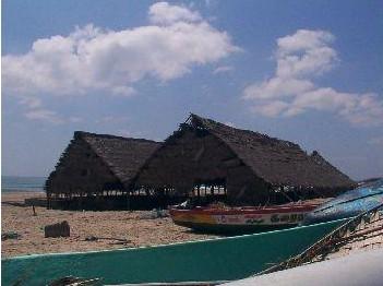
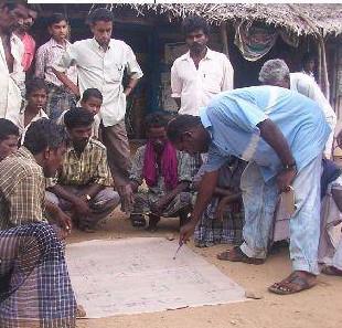
A rapid survey and GIS mapping was carried for the Eco-restoration sub-project of the Auroville Tsunami Project. Seven villages along the coast north of Pondicherry were surveyed. Villages were mapped using a GPS and participatory mapping tools. Tsunami related features such as temporary shelter locations, major structures in the village damaged and the tsunami line were mapped. The main focus of the study was to see if communities were willing to plant trees, water and protect them and if common areas were available for such planting. Areas identified for planting were thus also mapped using a GPS.
FERAL - once wild, runs wild again.


